
🇨🇭 Part of the Swiss Public Data MCP Portfolio
swisstopo-mcp





MCP server for Swiss federal geodata -- maps, elevation, geocoding, cadastral extracts, and downloadable datasets via Swisstopo APIs
Overview
swisstopo-mcp gives AI assistants access to Switzerland's official geodata infrastructure through 20 tools, all without authentication:
| Source | Data | API |
|---|---|---|
| Swisstopo REST API | 500+ geodata layers (buildings, boundaries, land use) | REST/JSON |
| Geocoding | Official addresses, place names, postal codes | REST/JSON |
| Height Service | Elevation above sea level, elevation profiles | REST/JSON |
| STAC Catalog | Orthophotos, elevation models, 3D buildings | STAC 0.9 |
| WMTS | National maps, aerial images, zoning maps | URL builder |
| OEREB Cadastre | Public-law restrictions, parcels | REST/JSON (cantonal) |
| geodienste.ch | Interkantonale Basisgeodaten (cadastral survey, contaminated sites, hazard maps, …) | OGC API Features / WMS / WFS |
| OpenStreetMap | Points of interest (schools, playgrounds, pharmacies, …) | Overpass API (ODbL) |
| OpenPLZ API | Administrative address level: postal codes → commune (BFS number) → district → canton | REST/JSON (BFS + swisstopo OGD) |
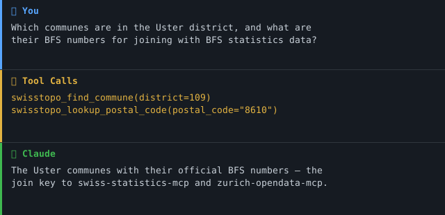
Anchor demo query: "Which communes are in the Uster district, and what are their BFS numbers for joining with BFS statistics data?"
(The BFS commune number is the official join key to swiss-statistics-mcp and zurich-opendata-mcp — this is what turns a geodata wrapper into a semantic connector at the commune level.)
→ More use cases by audience →
Demo
Features
- 🗺️ 20 tools (REST, Geocoding, Height, STAC, WMTS, OEREB, geodienste.ch, OpenStreetMap/Overpass, OpenPLZ)
- 🏛️ Resolve the administrative address level (PLZ → commune/BFS number → district → canton) via OpenPLZ
- 🔍 Geocode Swiss addresses and reverse-geocode coordinates
- 🏔️ Query elevation and compute elevation profiles
- 📦 Discover and download geodatasets (orthophotos, 3D buildings, historical maps)
- 🏗️ Identify map features at coordinates across 500+ Swisstopo layers
- 🔗 Generate shareable map.geo.admin.ch links
- 📋 Look up cadastral property IDs (EGRID) and retrieve OEREB extracts
- 🔓 No API key required for all tools (OEREB extract needs a supported canton)
- ☁️ Dual transport -- stdio (Claude Desktop) + Streamable HTTP (cloud)
Prerequisites
- Python 3.11+
- uv (recommended) or pip
Installation
# Clone the repository
git clone https://github.com/malkreide/swisstopo-mcp.git
cd swisstopo-mcp

# Install
pip install -e .
# or with uv:
uv pip install -e .
Or with uvx (no permanent installation):
uvx swisstopo-mcp
Quickstart
# stdio (for Claude Desktop)
python -m swisstopo_mcp.server

# Streamable HTTP (port 8000)
python -m swisstopo_mcp.server --http --port 8000
Try it immediately in Claude Desktop:
"Where is Bahnhofstrasse 1, Zurich? Give me the coordinates." "What is the elevation at the Uetliberg summit?" "What buildings are at coordinates 2683500, 1247500 (LV95)?"
Configuration
Claude Desktop
Edit ~/Library/Application Support/Claude/claude_desktop_config.json (macOS) or %APPDATA%\Claude\claude_desktop_config.json (Windows):
{
  "mcpServers": {
    "swisstopo": {
      "command": "python",
      "args": ["-m", "swisstopo_mcp.server"]
    }
  }
}
Or with uvx:
{
  "mcpServers": {
    "swisstopo": {
      "command": "uvx",
      "args": ["swisstopo-mcp"]
    }
  }
}
Config file locations:
- macOS:
~/Library/Application Support/Claude/claude_desktop_config.json - Windows:
%APPDATA%\Claude\claude_desktop_config.json
Cloud Deployment (SSE for browser access)
For use via claude.ai in the browser (e.g. on managed workstations without local software):
Render.com (recommended):
- Push/fork the repository to GitHub
- On render.com: New Web Service -> connect GitHub repo
- Set start command:
python -m swisstopo_mcp.server --http --port 8000 - In claude.ai under Settings -> MCP Servers, add:
https://your-app.onrender.com/sse
Available Tools
REST API (Layer & Feature Queries)
| Tool | Description |
|---|---|
swisstopo_map_query |
The national map catalogue (api3.geo.admin.ch). One operation per call — see the five below |
swisstopo_zoning_at |
Harmonised building zone at a coordinate — one call, no layer lookup (not legally binding) |
swisstopo_municipality_at |
Municipality, canton and official BFS number at a coordinate |
swisstopo_map_query operations
operation |
Answers | Required arguments |
|---|---|---|
search_layers |
Which layers exist for a keyword? (500+ catalogue) | query |
layer_info |
What fields can I query on this layer, and what is its legend? | layer |
features_at_point |
What is at this coordinate? | layers + a point (lat/lon or easting/northing) |
features_by_attribute |
Which features carry this value? (e.g. buildings by EGID) | layer, search_field, search_text |
feature_by_id |
Give me this one feature in full, with geometry | layer, feature_id |
Arguments belonging to a different operation are rejected, not ignored — the
error names the ones the chosen operation accepts. Silently dropping a
misplaced search_field would return a plausible answer to a question nobody
asked, which is the failure mode the whole envelope design is against.
Geocoding
| Tool | Description |
|---|---|
swisstopo_geocode |
Convert Swiss addresses, place names, or postal codes to coordinates |
swisstopo_reverse_geocode |
Find the nearest address for given coordinates |
Height Service
| Tool | Description |
|---|---|
swisstopo_get_height |
Get elevation above sea level (m a.s.l.) at a coordinate |
swisstopo_elevation_profile |
Compute an elevation profile along a line |
swisstopo_convert_coordinates |
Official WGS84 ↔ LV95 conversion via the swisstopo REFRAME service |
STAC Catalog (Geodata Downloads)
| Tool | Description |
|---|---|
swisstopo_search_geodata |
Search the STAC catalog for downloadable geodatasets |
swisstopo_get_collection |
Get details and download links for a STAC collection |
WMTS (Map URLs)
| Tool | Description |
|---|---|
swisstopo_map_url |
Generate a map.geo.admin.ch URL for browser display |
OEREB Cadastre
| Tool | Description |
|---|---|
swisstopo_get_egrid |
Resolve a cadastral property ID (EGRID) from coordinates |
swisstopo_get_oereb_extract |
Retrieve public-law land-use restrictions (OEREB) for a parcel |
Consolidated Geodata Façade
One façade over several map/layer sources, kept under the 25-tool budget (see
docs/geodaten-erweiterung-phase1.md):
| Tool | Description |
|---|---|
swisstopo_list_available_layers |
Discover layer keys for swisstopo_query_geodata (strassenverzeichnis, oereb-verfuegbarkeit, geodienste:<topic>:<canton>); filters to contract-free geodienste datasets |
swisstopo_query_geodata |
Query a chosen layer by point / bbox / commune — amtliches Strassenverzeichnis, interkantonale geodienste.ch data (OGC API Features), or ÖREB availability |
swisstopo_query_osm_features |
OpenStreetMap POIs (schools, playgrounds, pharmacies, …) around a point via Overpass — separate source, ODbL (© OpenStreetMap contributors) |
Administrative Address Level (OpenPLZ)
The amtliche address hierarchy PLZ → commune → district → canton, served by
the OpenPLZ API (data: BFS municipal directory +
swisstopo street directory, Swiss OGD — a separate source and licence from
the swisstopo geodata above). Every commune-bearing response exposes
bfs_commune_number as a named top-level field: the official join key to
BFS statistics (swiss-statistics-mcp) and zurich-opendata-mcp.
| Tool | Description |
|---|---|
swisstopo_lookup_postal_code |
Resolve a Swiss postal code → locality, commune (+BFS number), district, canton |
swisstopo_find_commune |
Resolve a commune both directions (name ↔ bfs_number) or list all communes of a canton / district. Accepts canton abbreviation (ZH) or key (1); resolution happens server-side |
swisstopo_search_address |
Full-text search over Swiss streets and localities, returning commune + BFS number per hit |
Example Use Cases
| Query | Tool |
|---|---|
| "Where is Bahnhofstrasse 1, Zurich?" | swisstopo_geocode |
| "What is the elevation at the Uetliberg summit?" | swisstopo_get_height |
| "What buildings are at coordinates 2683500, 1247500?" | swisstopo_map_query (operation='features_at_point') |
| "Find orthophoto datasets for download" | swisstopo_search_geodata |
| "Show me a map of Bern at zoom level 10" | swisstopo_map_url |
| "What restrictions apply to parcel at Musterstrasse 5?" | swisstopo_oereb_at |
| "Which schools are within 500 m of Bederstrasse 109, 8002 Zürich, and which streets lead there?" | swisstopo_query_osm_features + swisstopo_query_geodata (strassenverzeichnis) |
| "Which contaminated-sites data is free for canton ZH?" | swisstopo_list_available_layers + swisstopo_query_geodata (geodienste:kataster_belasteter_standorte:ZH) |
| "Which communes are in the Uster district and what are their BFS numbers?" | swisstopo_find_commune (district=109) |
| "Which commune and canton does postal code 8001 belong to?" | swisstopo_lookup_postal_code |
| "What is the BFS number of Winterthur (to join with BFS statistics)?" | swisstopo_find_commune (name=Winterthur) |
Architecture
┌─────────────────┐     ┌──────────────────────────────┐     ┌──────────────────────────┐
│   Claude / AI   │────▶│  swisstopo-mcp               │────▶│  Swisstopo REST API      │
│   (MCP Host)    │◀────│  (MCP Server)                │◀────│  api3.geo.admin.ch       │
└─────────────────┘     │                              │     ├──────────────────────────┤
                        │  20 Tools                    │────▶│  Geocoding               │
                        │  Stdio | Streamable HTTP     │◀────│  api3.geo.admin.ch       │
                        │                              │     ├──────────────────────────┤
                        │  No authentication required  │────▶│  STAC Catalog            │
                        │  (all tools; OEREB canton opt) │◀────│  data.geo.admin.ch       │
                        │                              │     ├──────────────────────────┤
                        │                              │────▶│  OEREB Cadastre          │
                        │                              │◀────│  (cantonal endpoints)    │
                        │                              │     ├──────────────────────────┤
                        │                              │────▶│  geodienste.ch (OGC API) │
                        │                              │◀────│  overpass.osm.ch (ODbL)  │
                        │                              │     ├──────────────────────────┤
                        │  BFS-Nr = join key to        │────▶│  OpenPLZ API             │
                        │  swiss-statistics-mcp        │◀────│  openplzapi.org (BFS/OGD)│
                        └──────────────────────────────┘     └──────────────────────────┘
Project Structure
swisstopo-mcp/
├── src/swisstopo_mcp/
│   ├── __init__.py              # Package version
│   ├── server.py                # MCP server wiring (tool registrations)
│   ├── api_client.py            # Shared HTTP client (httpx + error handling)
│   ├── geocoding.py             # swisstopo_geocode, swisstopo_reverse_geocode
│   ├── rest_api.py              # swisstopo_map_query (5 operations), zoning_at, municipality_at
│   ├── height.py                # swisstopo_get_height, swisstopo_elevation_profile
│   ├── stac.py                  # swisstopo_search_geodata, swisstopo_get_collection
│   ├── wmts.py                  # swisstopo_map_url
│   ├── oereb.py                 # swisstopo_get_egrid, swisstopo_get_oereb_extract
│   ├── geodata.py               # swisstopo_query_geodata + swisstopo_list_available_layers (façade)
│   ├── overpass.py              # swisstopo_query_osm_features (OpenStreetMap / Overpass)
│   └── openplz.py               # swisstopo_lookup_postal_code, swisstopo_find_commune, swisstopo_search_address (OpenPLZ)
├── tests/
│   ├── test_api_client.py
│   ├── test_geocoding.py
│   ├── test_height.py
│   ├── test_oereb.py
│   ├── test_rest_api.py
│   ├── test_stac.py
│   ├── test_wmts.py
│   ├── test_geodata.py
│   ├── test_overpass.py
│   ├── test_openplz.py
│   └── test_retry.py
├── .github/workflows/ci.yml     # GitHub Actions (Python 3.11/3.12/3.13)
├── pyproject.toml
├── CHANGELOG.md
├── CONTRIBUTING.md               # Contribution guide (English)
├── CONTRIBUTING.de.md            # Contribution guide (German)
├── SECURITY.md                   # Security policy (English)
├── SECURITY.de.md                # Security policy (German)
├── LICENSE
├── README.md                    # This file (English)
└── README.de.md                 # German version
Security & Limits
The full security policy and posture is documented in SECURITY.md.
Phase
This server is in Phase 2.5 — Consolidation of swiss-geodata-mcp
(see docs/roadmap.md, the single authority for phase state).
| Property | Status |
|---|---|
| Read tools | 24, all readOnlyHint: true / destructiveHint: false |
| Write tools | none — Phase 3, not planned |
| Transport | stdio (default) and Streamable-HTTP |
| ISDS classification | docs/isds-dsg.md — low protection requirement |
| DSG processing record | not maintained, with reasons — docs/isds-dsg.md §5 |
| Last audit | audits/2026-07-27T162602-Z-swisstopo-mcp/ |
A phase advance requires: the phase's roadmap items checked off, a re-run audit
with no open critical findings, and a CHANGELOG entry naming the new phase.
Phase 3 (write tools) additionally requires re-running the Lethal-Trifecta
assessment and a security review before any implementation starts.
Tool budget and aggregation
20 tools against a self-imposed budget of 25. The check's ideal is ≤12, so the count still needs an argument, not just a number. Per cluster:
The five api3 tools are merged (0.4.1, breaking). search_layers,
layer_info, identify_features, find_features and get_feature are now
operation values on swisstopo_map_query. They were the textbook
one-tool-per-REST-endpoint mapping the check names, and they are gone as such.
Earlier releases argued the opposite here, and the argument is worth keeping visible because it was not wrong so much as outweighed: merging relocates the decision from tool selection into schema navigation, where a model has less help, because tool descriptions are what it actually reads. Three things address that directly rather than hoping it does not matter:
- The operations are named for questions, not endpoints.
identifyandfindare ESRI vocabulary — they say which MapServer route is called, not what is being asked, and nobody without ArcGIS experience can tell them apart.features_at_pointandfeatures_by_attributecan be picked correctly from the operation list alone. - A misplaced argument is an error, not a silent drop. With five tools the schema made a wrong pairing impossible. With one tool it does not, so validation does: each operation declares the fields it accepts, and anything else is refused with a message naming the alternatives.
- The
notehints from ARCH-003 still name the next step, now as operations rather than tool names — an empty attribute search points atoperation='layer_info'for the valid field names, and so on.
Observability was the other cost, and it is not paid: each operation keeps its
own log and trace label (swisstopo_map_query:features_at_point), so per-operation
timing and error rates survive the merge.
The two pairs that stay separate, both named by the audit:
geocode+reverse_geocodedo hit the same SearchServer endpoint, so on the API axis this is a 1:1 mapping twice over. They stay separate on the axis that matters for tool selection: "address → coordinates" and "coordinates → address" are different questions with different input types, and collapsing them into one tool with a mode would make the model choose a variant instead of a tool. Sharing an endpoint is an implementation detail of the upstream.search_geodata→get_collectionis a genuine search → detail pair over STAC; see below.
The naming ambiguity is resolved, which the audit did not raise but the
previous version of this section recorded for "the next breaking release" — this
is it. swisstopo_search_layers and swisstopo_list_available_layers both said
"layers" while fronting different catalogues. The first is now
swisstopo_map_query with operation='search_layers', which puts the national
catalogue in the tool name and leaves list_available_layers unambiguously the
consolidated façade.
Search → detail pairs. search_geodata → get_collection is a genuine
pair: STAC collection metadata is large and callers usually want one of many
search hits. get_egrid → get_oereb_extract was the same shape and has been
collapsed: swisstopo_oereb_at answers the actual question in one call and
resolves the EGRID internally, because the EGRID is an upstream identifier
rather than something a caller asked for. get_egrid remains for callers who
want the parcel ID itself.
Genuine aggregation already in place. query_geodata fronts three sources
behind one tool; zoning_at and municipality_at each collapse a discovery
chain that previously took two calls.
When the next source is added, the choice is a raise or a consolidation.
With the api3 five merged there is no obvious consolidation left holding
headroom, so the next surface growth is a real conversation about the ceiling
rather than a deferred cleanup. tests/test_tool_namespace.py::TestToolBudget
is where that conversation is forced: raising the budget means editing the
number there and in both READMEs.
Data sources and licences
Every response carries source and license. ARE is a different federal
office from swisstopo, so its licence is asserted rather than inherited.
| Source | Served by | Licence |
|---|---|---|
| swisstopo / geo.admin.ch | most tools | Swiss OGD (opendata.swiss) |
| swisstopo REFRAME (geodesy.geo.admin.ch) | swisstopo_convert_coordinates |
Swiss OGD (opendata.swiss) |
| swissBOUNDARIES3D (swisstopo) | swisstopo_municipality_at |
Swiss OGD (opendata.swiss) |
ch.are.bauzonen (ARE) |
swisstopo_zoning_at |
Swiss OGD — Bundesamt für Raumentwicklung ARE |
| Cantonal ÖREB cadastre | swisstopo_get_egrid, swisstopo_get_oereb_extract, swisstopo_oereb_at, swisstopo_query_geodata |
Cantonal ÖREB terms |
| geodienste.ch (cantons) | swisstopo_query_geodata |
Free use — attribution required |
| OpenStreetMap (Overpass) | swisstopo_query_osm_features |
ODbL — © OpenStreetMap contributors |
| OpenPLZ (BFS + swisstopo) | swisstopo_lookup_postal_code, swisstopo_find_commune, swisstopo_search_address |
Free use — attribution required |
ch.are.bauzonen is a federal synthesis for cross-cantonal comparability and
is not legally binding — only the cantonal or communal Nutzungsplanung is.
That caveat is carried on every swisstopo_zoning_at result record.
Project structure
The tool modules sit flat under src/swisstopo_mcp/ rather than in a tools/
sub-package. Each module maps to exactly one upstream API family —
rest_api.py → api3 MapServer, stac.py → STAC, oereb.py → cantonal ÖREB,
openplz.py → OpenPLZ, overpass.py → OSM, coords.py → REFRAME — which is
the axis along which this server's code actually varies. A tools/ level would
add a directory without adding a distinction.
server.py contains tool registrations only; every tool body lives in its
domain module. Splitting it further is a readability question, not a structural
one.
Lethal Trifecta assessment
| Capability | Status | Rationale |
|---|---|---|
| Access to private data | ❌ No | Public Open Data only (federal/cantonal geodata) |
| Exposure to untrusted content | ⚠️ Limited | Reads only from a fixed allow-list of trusted geo.admin / OEREB hosts |
| External communication (write/send) | ❌ No | Read-only; no mail/webhook/write tools |
Trifecta score: at most 1 of 3 — safe by design.
Egress
Outbound requests are restricted to an explicit code-layer allow-list and redirects are disabled — see docs/network-egress.md.
Container deployment
For containerised HTTP deployments, a hardened Dockerfile and Kubernetes
manifests (non-root, read-only root filesystem, dropped capabilities, egress
NetworkPolicy) are provided — see docs/deployment.md.
MCP Protocol Version
The MCP protocol version is negotiated during initialize; the Python SDK does
not expose an author-settable pin. As of mcp 1.28.1 the negotiated version is
2025-11-25 (mcp.types.LATEST_PROTOCOL_VERSION). The SDK is pinned to the
1.x major in pyproject.toml so an update cannot silently move it, and
tests/test_protocol_version.py fails if it does — a Dependabot bump cannot
change the protocol version unnoticed.
Update policy
- SDK updates are tested on a feature branch before merge.
- A change to the negotiated protocol version is recorded in
CHANGELOG.md under
### Changed, naming the old and the new version. - A protocol change that breaks existing clients triggers a major release.
Sessions & Authentication
The server is unauthenticated by design — it serves only public open data. Over HTTP, session IDs are managed entirely by the FastMCP framework; there is no per-user state, so there is nothing user-specific to bind a session to. If an authenticated deployment is ever introduced, session IDs must be bound to the validated user identity (audit finding SEC-009).
Error handling
- Execution errors (upstream failure, invalid value) are returned as a
ToolResponsewithis_error: trueand a user-friendlysummary; unexpected exception text is masked and logged to stderr instead. No upstream body or internal configuration is forwarded: Overpass error pages are classified against a fixed signature table, and an egress refusal returns a fixed message rather than the allow-list (OBS-002). - Protocol errors (unknown tool, malformed/invalid arguments) come back from
the SDK as tool results with the protocol
isErrorflag set — not as JSON-RPC error objects. Verified against mcp 1.28.1 by runtime probe; an earlier version of this section claimed-32602and was wrong. Input validation happens at the Pydantic boundary (SEC-018). - Both flags agree. A handled execution error sets the protocol
isErrorflag and the payload fieldis_error, so a client can branch on either. The envelope — includingsourceandlicense— survives on the error path (OBS-001).
MCP Primitives
Tools are the surface, and almost all of it: every result is a live, parameterised API query rather than a static addressable document.
One Resource — swisstopo://catalogue/layers — serves the façade layer
catalogue. It is the one thing here that behaves like a document: deterministic,
idempotent, and already served with provenance: "cached". swisstopo_list_available_layers
remains for filtered queries; the resource is for a client that wants the
catalogue itself, addressably.
Two Prompts encode the workflows below, including the precedence rule for point questions. That rule lives in the tool descriptions and in the server instructions too, but a prompt is the one place a model reads it as guidance rather than as one of 24 descriptions (audit ARCH-007/ARCH-008):
| Prompt | Arguments |
|---|---|
swisstopo_feature_lookup |
ort, was |
swisstopo_geodata_download |
thema |
Tool workflows
Most tools return a thought-complete result in a single call. Two domains use a short, documented discovery chain (each tool's description states the next step):
- Feature query: all four steps are
swisstopo_map_querywith a differentoperation:search_layers(find layer IDs) →layer_info(see the queryable fields) →features_at_point/features_by_attribute→feature_by_id(full detail). - Cadastre:
swisstopo_geocode→swisstopo_oereb_at(one call: coordinates → EGRID → extract). Useswisstopo_get_egrid→swisstopo_get_oereb_extractonly when the parcel ID itself is wanted. - Downloads:
swisstopo_search_geodata→swisstopo_get_collection.
Response Format
Every tool returns a structured ToolResponse (FastMCP emits it as structured
content with an output schema, plus a JSON text block):
| Field | Meaning |
|---|---|
summary |
Human-readable Markdown summary |
results |
Machine-readable structured records |
count |
Number of results |
match_type |
exact / fuzzy / none (search-style tools) |
source / license |
Data attribution (OGD-CH, CC/OGD terms) |
provenance / retrieved_at |
How and when the data was obtained |
is_error |
true for handled errors |
Known Limitations
- OEREB tools require a canton parameter; not all cantons expose the same API format
- STAC catalog uses Swisstopo's v0.9 endpoint; some collections may lack complete metadata
- Geocoding covers Swiss addresses only (no Liechtenstein)
- Rate limits are enforced by Swisstopo; high-frequency usage may be throttled
Known findings — OpenPLZ live probe (2026-07-20)
The OpenPLZ endpoints were probed live before implementation. Findings baked into the tools:
| Endpoint / behaviour | Result | Handling |
|---|---|---|
/Cantons |
200, 26 records, key = BFS canton number (ZH = 1) |
canton abbreviation resolved from this list |
/Cantons/{key}/Districts|Communes |
200 | path param is the numeric key |
/Cantons/ZH/Districts (abbreviation) |
200 + [] — not an error |
ZH→1 resolved server-side; empty answer gets an explanatory note |
/Localities?postalCode=8001 |
200, commune.key = 261 (BFS Zürich) |
bfs_commune_number surfaced top-level |
/Localities?postalCode=9999 (unknown) |
200 + [] |
reported as a note — empty ≠ absent |
| list endpoints pagination | default pageSize=10, hard max 50 (100 → HTTP 400) |
tools iterate pages via x-total-count |
raw umlaut in query (?name=Zürich) |
HTTP 400 | httpx URL-encodes params automatically |
historicalCode field |
≠ key for communes (historized-directory id) |
not used; the join key is the current key |
| bulk dump | none from OpenPLZ (only /swagger) |
Architecture A (live-API-only) — adequate for a lookup connector |
The abbreviation-vs-key trap in one line: an empty OpenPLZ list is almost never proof that something does not exist — it usually means a wrong path parameter (an abbreviation where a numeric key was expected). The tools resolve abbreviations server-side and annotate every empty result.
Testing
# Unit tests (no network required)
pytest tests/ -m "not live"

# Integration tests (live API calls)
pytest tests/ -m "live"
Changelog
See CHANGELOG.md
Contributing
See CONTRIBUTING.md
Security
Read-only, no authentication, public geodata only. See SECURITY.md (Deutsch) for the security posture and how to report a vulnerability.
License
MIT License -- see LICENSE
Data provided by swisstopo under Open Government Data terms.
Author
Hayal Oezkan · malkreide
Credits & Related Projects
- Swisstopo: www.swisstopo.admin.ch -- Swiss Federal Office of Topography
- Swisstopo APIs: api3.geo.admin.ch / data.geo.admin.ch
- Protocol: Model Context Protocol -- Anthropic / Linux Foundation
- Related: zurich-opendata-mcp -- Zurich city open data
- Related: swiss-transport-mcp -- Swiss public transport
- Related: swiss-cultural-heritage-mcp -- Swiss cultural heritage
- Portfolio: Swiss Public Data MCP Portfolio
Installation
Run via uv's uvx — no clone or manual install needed. Add to your MCP client config (mcpServers for Claude Desktop, Cursor and Windsurf; use a top-level servers key for VS Code in .vscode/mcp.json):
{
  "mcpServers": {
    "swisstopo-mcp": {
      "command": "uvx",
      "args": [
        "swisstopo-mcp"
      ]
    }
  }
}
No comments yet
Be the first to share your take.